
Urban Stormwater Retrofit And BMP Validation
Hinkson Creek Urban Retrofit Project
Hinkson Creek is a dynamic stream system, with a drainage area of 90 sq. miles. This creek runs southwest through agriculture and pasture land, previous mining land, and urban land. The converted Katy Trail system and Flat Branch park recreational areas provides local residents with a connection to the creek system. The recent total maximum daily load (TMDL) discussions and excessive precipitation has focused the community's attention on the flooding problems and stream degradation issues in the watershed. Hinkson Creek has been on the 303(d) list since 1998 for unknown toxicity. In October 2011, the US Environmental Protection Agency (EPA) finalized a TMDL that identified the source of the impairment as urban runoff, and calculated a reduction in storm water runoff volume as a surrogate for any pollutants of concern. Infiltration, evaporation, and transpiration are the major transport mechanisms to remove the stormwater volume from the watershed. This project will attempt to quantify some of those mechanisms. The information will be useful for future urban TMDL's, Columbia and Boone County stormwater management, and engineering site designs.
Project Description
The goal of the project is to reduce flooding, improve water quality and health of the aquatic life of Hinkson Creek by implementing monitoring and retrofit activities identified in the Hinkson Creek Watershed Management Plan. The project will provide information to local citizens, especially the engineering community on the effectiveness of selected storm water practices by using local examples with quantifiable, repeatable monitoring data, including cost estimates.
Objectives
- Implement activities that will help achieve the goals of the Hinkson Creek TMDL, the Hinkson Creek Watershed Management Plan, and protect other streams in Columbia from nonpoint source pollution.
- Retrofit two areas with stormwater Best Management Practices (BMPs) to help reduce nonpoint source (NPS) pollution and hydraulic load to the receiving streams.
-
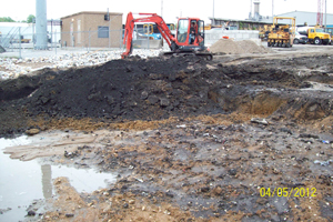
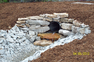 The Grissum area is a 10-acre city-owned site that currently does not treat stormwater runoff. This site will be retrofitted with at least six stormwater practices including bioretention or bioswales, underground detention, and pervious pavement. Additionally, an actively eroding channel will be stabilized via installation of a 300 ft-long step-pool storm-conveyance system.
-
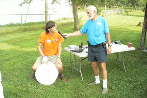
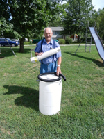
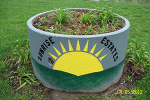 Sunrise Estates subdivision was built in the 1960-80s without stormwater controls. Lacking stormwater management, residents are experiencing problems with erosion from peak flows, flooding and permanently standing water. To reduce peak flows and flooding, this residential subdivision will be retrofitted with 65 rain gardens/rain barrels, 60 tree plantings, and three community stormwater treatment features over the 3-year grant period. Since many of these retrofits will occur on private property, this will be done on a volunteer basis, through cost-share with a required maintenance agreement.
-
-
Monitor the performance and water quality benefits of selected stormwater practices. This project has two distinct monitoring objectives. The first will be to characterize the reduction of common urban pollutants through selected practices. The second will quantify runoff volume reduction from installed retrofit practices in a residential subdivision. The overall goals of the water quality monitoring efforts are to provide Best Management Practice (BMP) performance information based on local climate and soil conditions.
- Provide BMP performance information to engineers, developers, city construction and maintenance staff, and state and local stormwater managers, so they can make informed decisions based on local conditions, (soils, rainfall, cost to install and maintain, public acceptance).
Cooperating Agencies
Boone County, City of Columbia, Missouri River Community Network, Columbia Volunteer Services, Missouri Society of Professional Engineers, Columbia Parks and Recreation Department, JobPoint, Missouri Department of Conservation, Missouri Academy of Professional Soil Scientists, Natural Resources Conservation Service, Sierra Club Water Sentinels, Missouri Department of Natural Resources, Geosyntec, Engineering Surveys and Services (ES&S).
Funding
The total project cost is $1,236,266. More than 58% (or $713,266) of the funding originates from a Section 319 grant provided by US EPA and administered by the Missouri Department of Natural Resources (DNR). The remaining 42% (or $526,000) comes from local contributions. These contributions include survey work, equipment usage, engineering design, educational programs, project management and volunteer time.

US Environmental Protection Agency Region 7, through the Missouri Department of Natural Resources, has provided partial funding for this project under Section 319 of the Clean Water Act. G11-NPS-12