
Protection of Environmentally Sensitive Areas in Boone County
What is an Environmentally Sensitive Area?
An environmentally sensitive area is any area in which plant or animal life or their habitats are either rare or especially valuable because of their special nature or role in an ecosystem. These areas may also contribute water to the habitat of an aquatic animal that is rare or valuable; or have increased vulnerability where proposed human activities could cause damage to the environment. Some examples would be where karst features are present, steep terrain, or highly erodible soils (Boone County Stormwater Ordinance, Section 2).
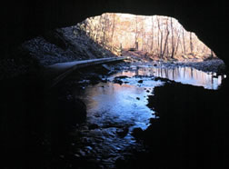
Karst features are formed when rainwater at the surface combines with carbon dioxide and makes a weak carbonic acid solution. This mildly acidic water finds its way down through cracks and joint in the bedrock and dissolves the surrounding limestone. Boone County has a system of karst topography west and south of Columbia. Karst structures found in this area are comprised of numerous sinkholes overlying a network of caves and losing streams (Soil Survey of Boone County, Missouri).
What is a sinkhole?
A sinkhole is a rounded depression in the landscape caused by collapsed underground caves. Sinkholes collect runoff from surface water that goes directly into groundwater. There are over 418 sinkholes in Boone County; most of which are located south of I-70 near Rocheport and Pierpont.
Boone County's Stormwater Ordinance requires that any runoff from development or redevelopment discharging to a groundwater recharge feature, such as a sinkhole or a cave, the land disturbance threshold is lowered to 3,000 square feet.
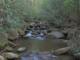
What is a losing stream?
A losing stream is one that delivers thirty percent (30%) or more of its flow to groundwater within two (2) miles' flow distance downstream of an existing or proposed discharge.
There are over 43 losing stream segments along Gans Creek, Fox Hollow Branch, Bonne Femme Creek, Slate Creek, Sinking Creek, Jemerson Creek, Bass Creek, and their tributaries. Losing stream segments can also be found in tributaries to Clear Creek, Fowler Creek, and Little Bonne Femme Creek.
According to the Stormwater Ordinance, when development or redevelopment is within 1000 feet of; or drains to an identified losing stream, the land disturbance threshold is dropped to 3000 square feet.
Class P Streams
Class P streams are streams that maintain permanent flow, even during drought conditions. Per the stormwater ordinance, the land disturbance threshold is dropped to 3000 square feet for any discharge or drainage from new development or redevelopment within 100 feet of a class P stream. The class P designation starts at the mouth of the river and includes the distance shown on the table below, in river miles.
Class P Streams in Boone County
| Waterbody Name | Miles |
|---|---|
| Bonne Femme | 7.8 |
| Hinkson Creek | 7.6 |
| Little Bonne Femme | 9 |
| Perche Creek | 11 |
| Perche Creek | 17.5 |
| Sugar Branch | 2.3 |
What are Outstanding State Resource Waters?
These are high quality waters that have a significant aesthetic, recreational, or scientific value. Outstanding State Resource Waters (OSRW) are specifically designated by the Clean Water Commission. All of the State Resource Waters in Boone County are associated with a Conservation Area (CA) or State Park (SP).
As stated in the Stormwater Ordinance for Boone County, any development or redevelopment is within 1000 feet of; or drains to an OSRW, the land disturbance threshold is dropped to 3000 square feet, and the required distance for the stream buffer setback is doubled.
Outstanding State Resource Waters in Boone County
| Waterbody Name | Miles | Location |
|---|---|---|
| Bass Creek | 1 | Three Creeks Conservation Area |
| Bonne Femme Creek | 2 | Three Creeks Conservation Area |
| Devils Ice Box Cave Branch | 1.5 | Rick Bridge Sate Park |
| Gans Creek | 3 | Rick Bridge Sate Park |
| Turkey Creek | 4.6 | Three Creeks Conservation Area |
US Fish & Wildlife Endangered Species List for Boone County
| Species | Status | Habitat |
|---|---|---|
| Gray bat (Myotis grisescens) |
Endangered | Caves |
| Indiana bat (Myotis sodalis) |
Endangered | Caves and mines; Maternity and foraging habitat: small stream corridors with well developed riparian woods; upland forests |
| Bald eagle (Haliaeetus leucocephalus) |
Threatened | Statewide in Winter |
| Pallid sturgeon (Scaphirhynchus albus) |
Endangered | Mississippi and Missouri Rivers; Sturgeon will travel upstream into Perche Creek during flood events |
| Running buffalo clover (Trifolium stoloniferum) |
Endangered | Disturbed bottomland meadows |
| Topeka shiner (Notropis topeka) |
Endangered | Small prairie (or former prairie) streams in pools containing clear, clean water. Most Topeka shiners are found in perennial streams (flow year-round), or streams maintained by groundwater seepage. Topeka shiners need streams with clean gravel, rock, or sand bottoms. |