
Map Library
Below are a few examples of the many maps the GIS Department has made for various entities and purposes.
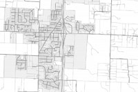
Boone County Plat Book
Plat books are a collections of maps that features township level ownership and reference maps, city area maps, County road map, park maps, referenced maps, and road and owner index lists. These two maps are examples of the ownership and reference maps that are included in the book. The book is published by the Boone County Assessor’s Office as a guide to the community and will be updated on a yearly basis. The full version of the plat book may be viewed and downloaded through the Boone County Assessor’s website.
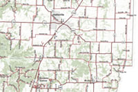
Boone County Road and Subdivision Map
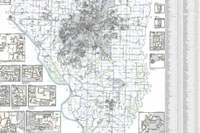
The Boone County Road and Subdivision Map is a county-wide map showing roads and subdivisions located in the county. Includes detail maps of certain subdivisions to show the specific road network in those areas and an index listing of all the county subdivisions.
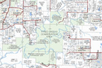
Boone County Ownership Map
The Boone County Ownership Map is a county-wide map showing ownership information and other geographic features including parcels, roads, hydrology, municipalities, parks and conservation areas.
Boone County Imagery Map
The Boone County Imagery Map is a county-wide map that shows the latest available imagery, which is currently 2019 orthophoto. It also highlights other imagery data available through the county, including LiDAR and historic aerial imagery.
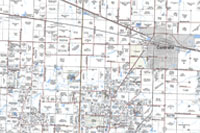
Boone County Quick Reference Road Map
The Boone County Quick Reference Road Map is a county-wide map book showing roads located in the county.
VR Map Gallery
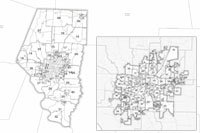
Boone County Voting Registration provides a variety of maps created for viewing current voting district information for Boone County including precinct, commission districts and legislative districts. These two maps were created to display the voting precincts in Boone County and in City of Columbia. A full listing of available maps may be found on the Boone County Clerk website.
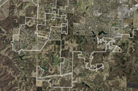
3-D Mapping Products
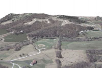
These 3D maps were created by draping Boone County’s Orthophoto Imagery over LiDAR elevation data. Other types of maps and analysis that can be utilized with Lidar data include visualizing elevation, slope, aspect, viewsheds, and contour lines.
Boone County Parcel Map
A sample parcel map from the 534 1:100, 1:200, and 1:400 scale maps produced annually for the Boone County Assessor's Office. Individuals can purchase up to date copies of parcel maps in the Assessor’s Office.
City of Ashland Road Map
The City of Ashland Road Map is a large format map of the City of Ashland including boundaries, roads, and parcels.
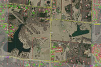
Boone County Internet Mapping Viewers
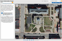
The internet mapping system is powered by a multi-tier ArcGIS Server implementation and features a direct connection to the Boone County Assessor’s computerized tax system for ownership and tax information, and to the County ArcGIS Server system for all GIS datasets.
With the Parcel Information Viewer one can view Boone County from the air and have the ability to locate property and zoom in for a closer view (with or without displaying the aerial photo). Then, with a few clicks of the mouse, one can display a property's owner information and tax history. The parcel linework is updated daily. The Aerial Photo Viewer doesn’t include parcel information, which may be useful if a less cluttered map is desired.
Boone County Facility Locations
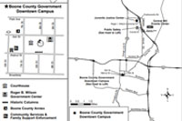
The Boone County Facility Locations Map is a general map to aid in finding Boone County Facility Locations, including the Government Downtown Campus, Public Works, and the Sheriff's Office.
Zoning Map
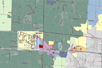
This Zoning Map was created to show the zoning areas and classifications for land-use planning in the county. Includes reference data such as roads, public land survey grid (section, townships, and ranges), parcels, and municipal boundaries. Also includes detail maps of subdivision areas to show the specific zoning areas in those locations.
Boone County 2007 Flooding
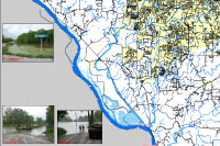
The Boone County 2007 Flooding map is a map of the 2007 flooding developed by the Columbia/Boone County Office of Emergency Management with assistance from the Boone County GIS Department.
Hinkson Impervious Surfaces
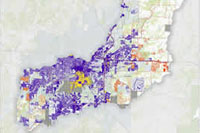
The County is engaged with the City of Columbia and University of Missouri to improve the quality of water in Hinkson Creek. An analysis was made using GIS data to determine the length of impaired section and the amount of the impaired surface area within the Hinkson Creek watershed in each partner’s jurisdiction/entity, resulting in the creation of the Hinkson Impervious Surfaces map.