Storm Images
Unstable Atmosphere
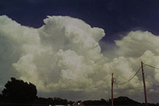
When the atmosphere is unstable, thunderstorms form in sudden, billowing masses of white vapor. Here, you see an image of a developing storm. Over the continental United States, storms can reach heights of 60,000 feet — twice the cruising altitude of a passenger jet! Or, another way to think of it: at 60,000 feet, you have shot above the troposphere (the layer of atmosphere in which we live) and have entered the stratosphere!
Wall Cloud
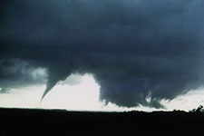
The wall cloud is a low-hanging, rotating feature below the base of the thunderstorm updraft. "Wall" is probably not a good descriptive word for it, but an early and better characterization, "pedestal," never caught on. A wall cloud often precedes the formation of a tornado. Here, the tornado on the left is roping out as the wall cloud on the right organizes further and strengthens. Out of the shaggy cloud, a new tornado will appear.
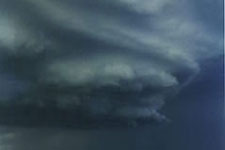
Driving Through a Storm
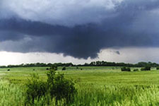
If you were driving through an April storm and saw this cloud, you might very well pass below it without a second thought. But this shaggy, dangling wall cloud portends danger: This storm produced a tornado minutes earlier. A motorist crossing the plains in spring should always be alert to changing weather conditions and to thunderstorms with cloud features that signal organized activity on a large scale.
Lightening
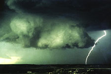
Lightning snaps to the ground beside this well-defined wall cloud. This makes for more than a dramatic picture. Over the years, meteorologists have pondered whether lightning, in some way, helps spawn tornadoes. While the theory sounds exciting, it has fallen severely out of favor with leading researchers, and no direct connection between lightning and the formation of tornadoes is believed to exist.
Updraft Trunk
The appearance of the updraft trunk of a supercell storm has been described by storm chasers as looking like "stacked plates." In this picture, that dangerous, smooth, striated look is very much in evidence. This rotating storm in the Texas Panhandle later lowered a brief tornado (luckily, of little strength) on top of a caravan of surprised meteorologists observing its behavior up close.
Supercell
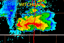
In this loop you can see a beautiful image of a supercell thunderstorm producing a large tornado, which was confirmed by storm spotters on the ground. The red hook echo is very prominent, with the storm arched to the north in the middle and the entire thunderstorm spinning counterclockwise. In the last frame a small circle at the vortex reveals the tornado itself.
Computer Simulation
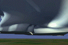
Here is a computer simulation of a tornado, courtesy of the Scientific American Explorations web site. Notice the rotation of the clouds and how the funnel cloud descends from the cloud base.